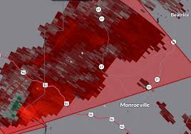
A tornado warning is currently in effect for areas near the Alabama River west of Claiborne along the Clarke and Monroe County line. This potential tornado is expected to pass northwest of Monroeville. As of the latest update, a severe thunderstorm capable of producing a tornado was detected 9 miles southeast of Whatley, moving northeast at a brisk pace of 55 mph. Radar data has highlighted significant rotation within this storm, indicating the possibility of a tornado formation.
Residents in northwestern Monroe County and east central Clarke County in southwestern Alabama are advised to take immediate precautions. The storm has the potential to cause flying debris, structural damage to buildings, vehicles, and mobile homes, as well as uproot trees. While the storm is forecast to primarily impact rural areas, those in its path must seek shelter promptly.
For individuals within the warned area, it is recommended to seek refuge in an interior room on the lowest level of a sturdy building, while keeping away from windows. Given the challenging visibility at night, action should be taken without visual confirmation of the tornado. The safety of individuals in the affected region is paramount, and following these precautions is vital to minimizing potential risks associated with severe weather events.
The weather situation is being closely monitored, and further updates will be provided as new information becomes available. For ongoing updates and alerts, monitoring local news sources and weather platforms is advised. Additionally, residents are encouraged to adhere to safety guidelines issued by relevant authorities to ensure their well-being during severe weather occurrences.
UPDATE – 6:30 p.m. Wednesday:
The latest weather developments indicate that the current activity in the Metro Area has stayed below severe thresholds due to earlier rain stabilizing the atmosphere. While tornadoes have been reported in southern Mississippi, the main line of showers and thunderstorms is projected to move eastward, with the severe weather threat diminishing progressively from west to east.
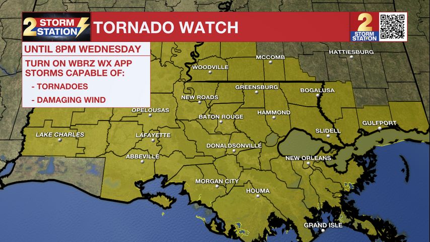
A tornado watch is still in effect for various parishes and counties until 8 p.m. Wednesday, suggesting favorable conditions for tornadoes and damaging winds in the specified areas. Residents in these regions are advised to stay vigilant and heed any subsequent warnings. As the evening progresses, a cold front is forecast to drive a line of storms through the Capital Area, potentially bringing damaging winds and brief tornadoes.
Looking ahead to Valentine's Day, temperatures are expected to remain relatively cooler but near normal for this time of year, with highs in the mid-60s. Although rain is not anticipated, increased cloud cover may occur due to upper-level moisture interacting with a stalled front. Moving into the weekend, warm and breezy conditions are forecast, with temperatures possibly reaching record highs before a cold front sweeps through, bringing the potential for severe thunderstorms.
As the weekend progresses, the severe weather threat may intensify, with the possibility of severe weather extending into Mississippi and north of Baton Rouge. The Storm Prediction Center highlights significant potential for severe weather on Saturday, with details expected to become clearer as the responsible disturbance progresses across the West Coast.
In the broader weather outlook, 1-3 inches of rain are projected over the next week, though the fast-moving nature of the weather systems should prevent widespread flooding concerns. For the most up-to-date forecast and real-time weather updates, stay connected with local news sources and weather platforms.
The Storm Station team continues to provide comprehensive weather coverage on various platforms, including News 2, wbrz.com, the WBRZ WX App, and social media channels. By following these outlets, individuals can stay informed and prepared for changing weather conditions in their area.