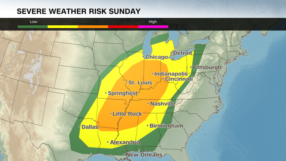
A brewing storm system threatens to unleash a wave of severe weather across the central United States over the next few days, putting approximately 170 million people on high alert. This dramatic weather event is set to bring severe thunderstorms packing tornadoes, large hail, and damaging winds to regions stretching from Illinois to eastern Texas and beyond.
The spate of tornado reports in March has already surpassed last year's numbers, heightening concerns for the safety of residents in areas previously hit by deadly storms earlier in the month. The unusual warmth that has enveloped the Midwest to the East Coast is expected to abruptly end as a potent cold front sweeps through on Sunday, sparking explosive thunderstorms as warm, moist air clashes with the oncoming cooler air mass.
The Storm Prediction Center has issued severe weather warnings for over 25 million people under a level 3 out of 5 risk category, emphasizing major cities like Nashville, Indianapolis, and St. Louis that are in the storm's path. An additional 40 million individuals are under a level 2 out of 5 risk, including cities such as Dallas, Chicago, and Cleveland.
Pictures captured near Oklahoma City already show massive hailstones ranging from the size of a quarter to a golf ball, indicating the intensity of the storms. As the system progresses eastward on Sunday, the severity of the storms is expected to escalate, potentially leading to strong and long-lived tornadoes, large hail, and destructive wind gusts.
With a significant number of people under tornado watches across multiple states, residents in high-risk areas are urged to stay vigilant and prepared for possible severe weather events. The threat of flash flooding is also looming over the South and Midwest due to heavy rainfall predicted in some regions.
As the storm system pushes eastward into Monday, the severe weather hazard will extend from the Appalachians to Louisiana and Mississippi, affecting a vast population and encompassing cities across the East Coast. The primary threats vary by region, from damaging wind gusts in the Northeast to a mix of severe weather in the South, including hail, tornadoes, and strong winds.
This year has already seen a sharp increase in tornado activity compared to previous years, with an alarming number of tornado reports logged since January. Considering the rising trend, meteorologists are closely monitoring additional regions for potential thunderstorm activity later in the week.
Residents in at-risk areas are strongly advised to stay informed through reliable weather sources and have multiple channels to receive timely weather alerts, including preparations for nighttime storms that pose a higher risk of fatalities. The ongoing storm coverage provided by FOX Weather's meteorologists, Haley Meier and Steve Bender, aims to keep the public updated on the evolving weather situation.
As the severe weather outbreak unfolds, NBC News reports that a large population spanning the Mississippi, Ohio, and Tennessee Valleys could potentially be affected by the storm system, with warnings of destructive wind gusts, large hail, and strong tornadoes. The National Weather Service's Storm Prediction Center highlights multiple cities at risk, emphasizing the potential for very large hail, significant damaging winds, and the likelihood of tornadoes, some of which may be intense.
The storm's progression from the Midwest to the Southeast and mid-Atlantic is expected to bring severe weather to 68 million individuals, with cities like Charlotte, Atlanta, Philadelphia, and New Orleans under the threat zone for damaging winds and tornadoes. Meanwhile, wintry precipitation persists in parts of the Upper Midwest, Great Lakes, and New England, impacting millions with snow and ice alerts.
In the Western United States, millions of people are under alerts due to anticipated wind gusts that raise fire concerns, particularly in Colorado, New Mexico, and West Texas. High fire danger remains a focal point for authorities in these regions, necessitating precautionary measures to prevent potential disasters.
Overall, the ongoing severe weather situation underscores the importance of staying vigilant, prepared, and well-informed in the face of unpredictable weather patterns. With meteorologists and weather authorities closely monitoring the evolving conditions, the safety and well-being of residents remain paramount in navigating through these challenging weather scenarios.

