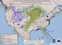
Severe weather continues to wreak havoc across the central U.S., with millions of Americans in the path of damaging winds, large hailstones, and tornados. The National Weather Service confirmed a tornado near Augusta, Wis., and issued tornado watches and warnings for states like Iowa, Minnesota, South Dakota, and Wisconsin.
The Storm Prediction Center rated the risk of severe storms in the Twin Cities as 4 out of 5, highlighting the likelihood of tornadoes, hail, and damaging winds. Despite reports of large hail and tornados, Minnesota was mostly spared. This severe weather outbreak, covering the southern Plains to the Northeast, poses a significant threat to various regions.
Moreover, the NWS Weather Prediction Center forecasts heavy rainfall in northern Texas and the Ozarks, potentially leading to catastrophic flooding. The alert extends to southwest Oklahoma, while severe thunderstorms are possible from the lower Great Lakes to the southern High Plains.
As the system moves, additional tornado watches and warnings have been issued in northern Texas, northeast Oklahoma, and northwest Arkansas. Moreover, the Ohio Valley and Northeast face the risk of large hailstones, damaging winds, and isolated tornadoes. Cities like Buffalo, N.Y., Cincinnati, Cleveland, Detroit, and Pittsburgh are likely to experience severe impacts.
Looking ahead, a second system is projected to bring severe weather to the Plains, affecting millions from northern Texas to southern Missouri with threats of large hailstones, damaging winds, and tornados.
Across Central New York, meteorologists are warning of strong and severe storms expected on Tuesday, with temperatures reaching the year's warmest so far before thunderstorms arrive. The region could experience much cooler weather on Wednesday as a cold front sweeps through. The Storm Prediction Center has placed central and western New York under an Enhanced risk of severe thunderstorms, hinting at strong damaging winds, heavy rain, and a potential tornado threat.
The tornado probability within 25 miles has increased to 5%, urging residents to have safety plans in place. As cooler temperatures follow the front passage, residents are advised to stay weather aware and monitor live local radar for updates.
In Buffalo, N.Y., a Weather Impact Alert has been issued for potential severe storms with risks of heavy rain, damaging winds, hail, and possibly a brief tornado. As a strong cold front approaches, the area faces the possibility of strong to severe thunderstorms between 1 pm and 9 pm. The threat includes damaging winds, large hail, and a slight risk of tornados, especially in areas south of Buffalo and inland.
Residents are advised to stay updated through local news outlets and weather apps for the latest information. Stay safe and prepared for severe weather conditions as they sweep across these regions.