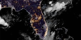
The National Hurricane Center cNHCc is closely monitoring a storm system off the southeastern U.S. coastline due to its potential for tropical development as it tracks across Florida and into the Gulf. This disturbance, reminiscent of what was previously known as Invest 93L earlier in the month, originates from a trough of low pressure at the southern end of a frontal boundary. The NHC forecasts its movement towards the west-southwest into the north-central Gulf, where environmental conditions could support slow development if the system remains sufficiently offshore.
Meteorologists from FOX Weather, Haley Meier and Craig Herrera, provided insights on the forecast for July 23, 2025. While this system currently shows a low chance of intensification, the threat of heavy rain and thunderstorms lingers if it evolves into a tropical system. Rainfall estimates suggest about 2-3 inches across the northern Gulf Coast, with localized higher amounts. Although widespread flash flooding is not anticipated, isolated flooding is possible in areas experiencing prolonged heavy precipitation.
Comparing this disturbance to Invest 93L, the current system appears to have a lower likelihood of development due to its less organized structure. However, the persistent southerly flow along the northern Gulf is expected to create an increased risk of rip currents along beaches in the area. A medium risk of rip currents is forecasted along the Florida Panhandle and several areas along the Atlantic coast until the end of the month.
Some regions have already experienced flooding, such as the South Carolina Low Country, where higher tides combined with heavy rainfall resulted in street flooding around Charleston. Additionally, downtown Charleston received over an inch of rain recently, leading to minor saltwater flooding around Charleston Harbor. These impacts are expected to continue until the disturbance moves through the Gulf region.
Looking ahead, a stretch of low pressure, described as a trough by meteorologists, will traverse Florida and move towards the northern Gulf Coast in the coming days. Although there is a slight chance of it developing into a tropical depression or storm, the primary concern is the potential for tropical downpours across the region. The disturbance is expected to produce heavy rain from Florida to southeast Louisiana, with a risk of isolated flash flooding and gusty winds.
For beachgoers, there will be an elevated rip current threat along the Florida Panhandle, Alabama, and Mississippi beaches. It's advised to pay attention to the color-coded flags displayed on beaches to indicate the level of risk associated with rip currents. These precautions are essential as strong rip currents pose a danger to swimmers and beach enthusiasts along these coasts.
In contrast, South Mississippi is not expected to experience significant impacts from the tropical disturbance. However, the increase in tropical moisture may lead to afternoon storms from Wednesday to Friday, offering relief from the scorching temperatures that have plagued the region. The addition of clouds and scattered storms is predicted to lower temperatures by 5-10 degrees, bringing highs back to the upper 80s to low 90s on Thursday and Friday.
In conclusion, while the likelihood of tropical development remains uncertain, the influence of this disturbance is already affecting weather patterns along the Gulf Coast, prompting residents and visitors to stay informed about potential risks and local forecasts. Stay updated on the latest developments to ensure preparedness for any changing conditions in the region.