Weather Forecast for Boston Area
As the weekend approaches, Boston and its surrounding areas are in for some notable weather shifts. A system is currently on the horizon, set to bring steady rain throughout the night and into early Halloween on Friday. The southern regions of the area should expect the rain to clear up in time for trick-or-treating activities. However, the weather is predicted to turn windy on Friday night and into Saturday.
In the immediate forecast, we anticipate increasing clouds today with a possibility of a stray shower or two, along with beneficial rain—potentially exceeding an inch in some areas—expected tonight. Additionally, there could be a period of gusty winds, especially along the western slopes. Although some rain might persist into early Friday, it seems likely that things will dry out for many by the time Friday evening rolls around. Despite the clearing skies, a breezy atmosphere is to be expected by then.
Following this system, the winds are forecasted to intensify on Friday night and through Saturday, with gusts potentially exceeding 35 MPH. Showers may linger in the northern parts on Saturday while drier conditions with lighter winds are projected for Sunday. Weekend highs are predicted to range from the 40s to lower 50s.
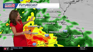
Looking at the envisioned weather conditions for the upcoming days in Boston, Thursday's forecast indicates a worrisome start with wet weather expected to return at or before dawn. Several computer models suggest the likelihood of a significant amount of rain on Thursday, hinting at a potential washout across the region. This forecast is especially promising news for areas in Upstate New York suffering from moderate to severe drought conditions.
On Thursday, temperatures are set to remain in the 40s during the day and rise to the lower 50s by nightfall. Some scattered showers are anticipated Thursday evening, followed by a short period of calmness and dry weather late into Thursday night and parts of Friday morning. Nevertheless, the nearby intensification of the system may bring about blustery westerly winds on Friday and persist into Friday evening, coinciding with Halloween celebrations.
Expect temperatures in the lower to middle 40s during trick-or-treat time, accompanied by sustained winds of 15-25 MPH and gusts reaching 30-40 MPH. Wind chills are likely to dip into the lower to middle 30s. A strengthening system moving away might bring wrap-around precipitation and potential lake-effect rain on Friday afternoon, impacting areas north of Route 31. Moreover, there is a chance for snow in the Tug Hill Plateau and some parts of the Adirondacks on Friday night, possibly leading to slushy accumulations. Therefore, it is advised to dress appropriately for the cold and windy conditions.
This year's Halloween weather will be quite different from last year's record high of 81 degrees in Syracuse. Though this Halloween may not be the coldest or snowiest, it certainly presents its own challenges. As such, residents are encouraged to stay informed and updated about the forthcoming weather conditions.
For a detailed look at the forecast ahead, you can refer to the latest update provided by Meteorologist Peter Hall. Stay prepared and stay safe as you navigate through the changing weather patterns in the Boston area.