Nashville, Tenn. is currently facing a Code Red Weather Alert, as FOX 17 News has issued a warning for a tornado watch and severe storms. Accompanied by a severe thunderstorm warning for Dickson, Cheatham, and Williamson counties, residents are advised to brace themselves for potential heavy rain, winds up to 60 mph, and the possibility of small hail. While the severity of these thunderstorms may remain relatively low, the primary threat lies in damaging winds. The FOX 17 News viewing area is currently at a 2 out of 5 risk level for severe weather, with ongoing storms expected to develop between 2-10 p.m. Specifically, Davidson County is projected to experience these storms between 4-6 p.m.
A tornado watch was also issued by the National Weather Service, extending its effects until 10 p.m. for counties including Jackson, Lauderdale, Limestone, and Madison. Understanding the distinction between a Tornado watch and a Tornado warning can be crucial during these moments of potential danger. A Tornado watch signifies the need for preparation, while a Tornado warning indicates immediate action must be taken. Being well-informed about these alerts is vital for ensuring safety during tornado season.
To safeguard against tornado risks, several safety measures can be adopted. Staying abreast of weather forecasts, signing up for notifications, establishing communication plans, choosing secure shelters, and conducting family drills can all help in preparing for potential tornado threats. Enforcing these measures can greatly enhance readiness and reduce risk in the face of severe weather conditions.
In the event of a tornado strike, swift and informed action is paramount to ensuring personal safety and minimizing potential harm. Staying aware of weather updates, seeking refuge in secure locations at home, work, or school, and avoiding unsafe areas if caught outdoors are essential steps to take to mitigate risks associated with tornadoes. Following the guidelines provided by the weather service can significantly enhance one's safety during tornado occurrences.
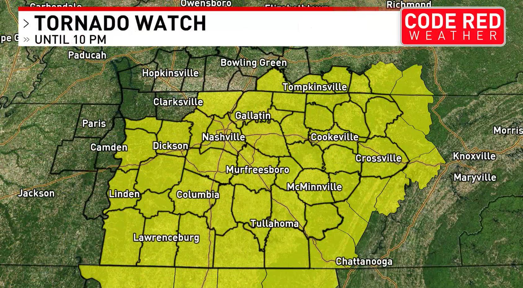
As the National Weather Service continues to monitor the situation, a tornado watch remains in place for a significant portion of middle Tennessee and southern Kentucky until 10 p.m. on Friday night. The storm prediction center has indicated that areas such as northern Alabama could also be affected by severe weather conditions, including threats of large hail, damaging winds, and possible tornadoes.
NWS Nashville has specifically highlighted the possibility of severe thunderstorms in areas like Dickson, Fairview, and Ashland City, Tennessee, throughout the duration of the tornado watch. While the primary threats are currently identified as damaging winds and large hail, the potential for tornadic storms should not be completely disregarded, urging residents in these areas to remain vigilant.
Likewise, various counties in Tennessee have been identified as likely to be impacted by the severe weather conditions, along with a small area in southern Kentucky. Residents in the listed counties are advised to stay alert and proactive in their response to the unfolding weather situation.
Ultimately, staying vigilant, prepared, and responsive to weather alerts and warnings is crucial in ensuring personal safety and mitigating risks during severe weather events like tornadoes. By adhering to safety protocols, communication plans, and established guidelines, individuals can better equip themselves to navigate through such challenging weather conditions with resilience and caution. As the situation continues to evolve, staying informed and proactive will be key in navigating through potential impacts and ensuring the well-being of communities at risk.