As Southeast Michigan recovers from a snowy blast, schools in Metro Detroit are bracing for potential closures on a second consecutive day due to the freezing temperatures that could lead to icy road conditions. While the snowfall has ceased for now, the region is gearing up for plummeting temperatures and single-digit wind chills.
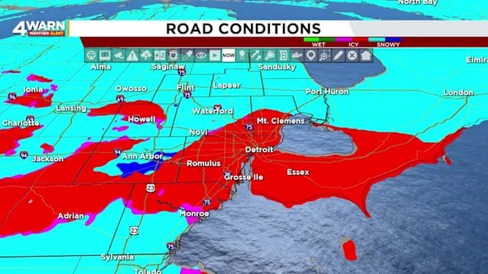
Following a brief rise above freezing on Wednesday after nearly two weeks of below-freezing temperatures, the snow turned into rain, creating slushy roadways. However, with temperatures now dropping and staying below freezing for the foreseeable future, the rainwater is expected to freeze, resulting in hazardous icy conditions across the area.
As night falls over Southeast Michigan, temperatures are set to dip into the teens by Thursday morning, accompanied by even lower wind chill values, making it feel like single digits in Metro Detroit. The rapid temperature decline after the slight thaw on Wednesday is a stark reminder of the harsh winter weather that residents in this region often face.
The inclement weather conditions have led to numerous school closures, providing some students with an unexpected day off. By 9:30 p.m., multiple schools had already announced closures, underscoring the impact of the extreme weather conditions on daily life in the area.
Meteorologist Bryan Schuerman's detailed weather forecast highlights the ongoing challenges posed by the weather patterns, with areas such as Livingston, Macomb, and Oakland Counties facing an expanded winter weather advisory due to ongoing snowfall. The advisory underscores the continued impact of the weather system as snowfall totals are expected to increase in these regions.
Looking ahead, the forecast predicts a mix of rain and snow for some areas on Wednesday, gradually transitioning into snow as temperatures drop during the afternoon and evening. With concerns about potential refreezing as temperatures fall below freezing again, caution is advised for commuters as the evening progresses.
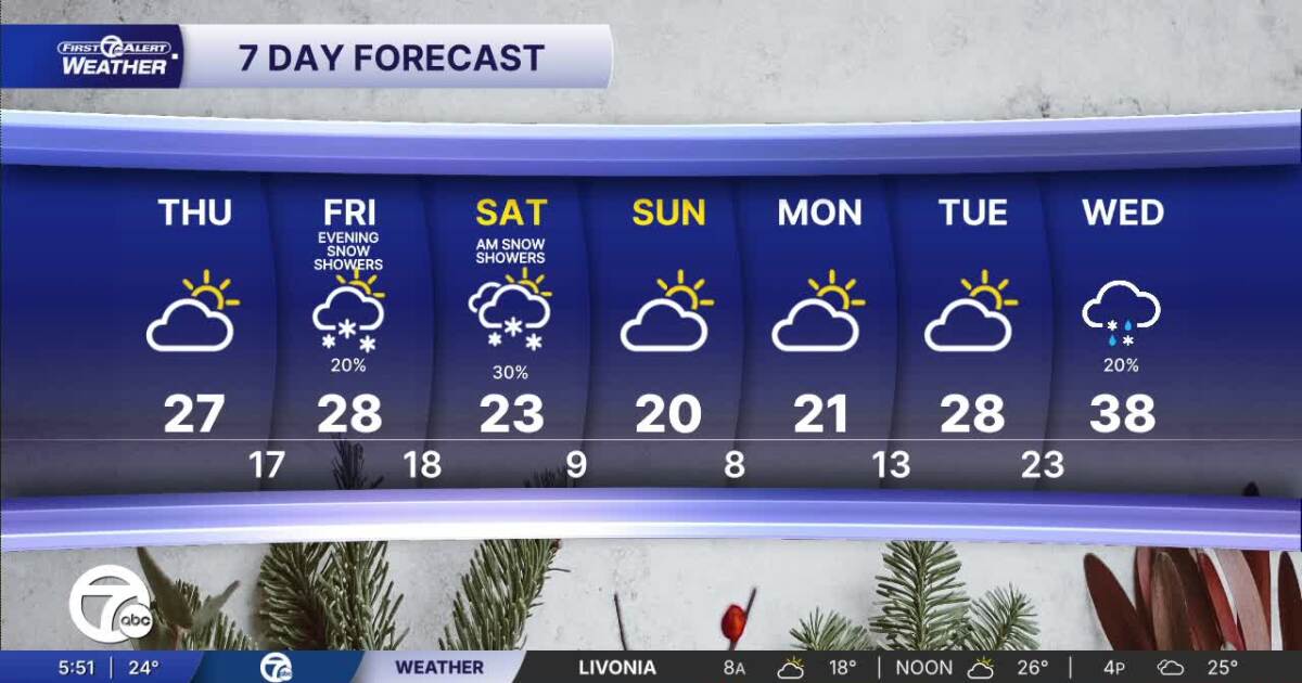
The outlook for Thursday remains cold and snowy, with the possibility of isolated snow showers and low temperatures in the teens. The following days are expected to bring further snow chances, with temperatures dropping to single digits overnight on Sunday and Monday, accompanied by potentially below-zero wind chills.
While a brief respite with some sunshine is anticipated by Sunday, the following week is projected to remain mostly cloudy with a slight temperature increase. By Tuesday, temperatures are expected to rise into the upper 20s to lower 30s, marking a slow return to slightly milder conditions after the wintry spell.
In conclusion, the severe weather conditions in Metro Detroit highlight the challenges of navigating through a winter storm, emphasizing the importance of preparedness and caution in the face of freezing temperatures and icy roads. Stay informed with reliable weather updates and take necessary precautions to stay safe in the midst of these challenging weather conditions.