A wintry blast is sweeping through the Bluegrass region, bringing cold temperatures, snow showers, and slick road conditions to the Louisville and Lexington areas. As residents wake up to partly to mostly cloudy skies in Louisville, temperatures are holding steady in the 20s with wind chills making it feel even colder, remaining in the teens. Some flurries and snow showers may persist in areas where clouds linger, hinting at the impending weather changes.
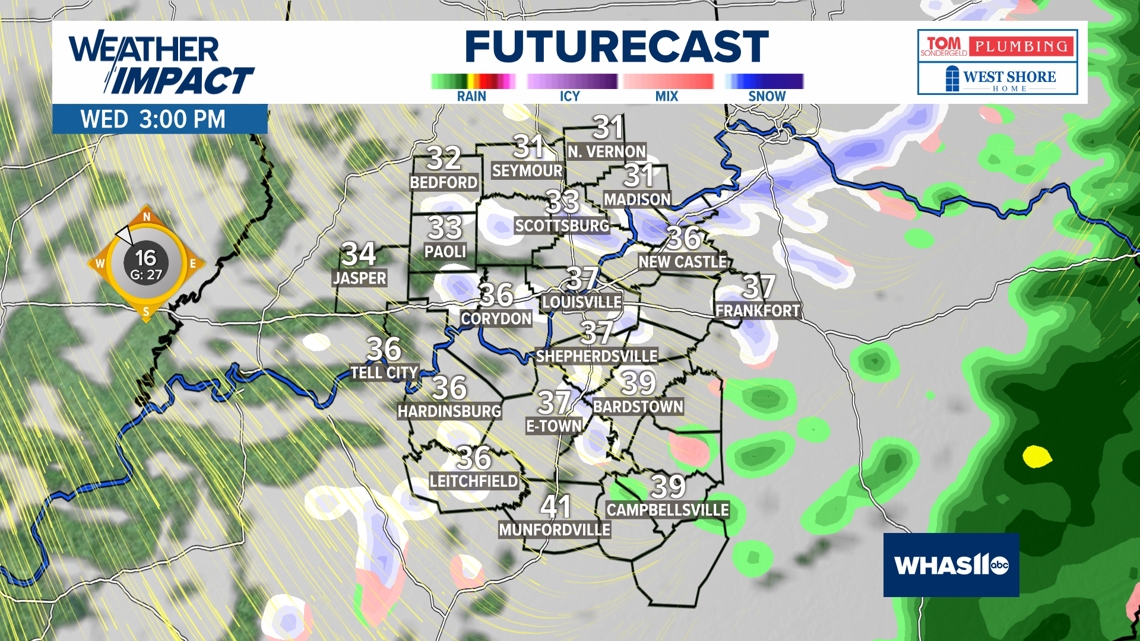
Looking ahead, a shift in the weather pattern is expected as clouds begin to increase in the evening in Louisville, heralding the approach of a warm front. Overnight lows will dip into the teens and 20s while snow is anticipated to make a comeback in the region post-midnight, setting the stage for a snow-filled Friday morning. The day is slated to see snowfall leading to potentially hazardous travel conditions, prompting a WAVE Weather Alert Day to be declared. As the mercury makes its way into the upper 30s and low 40s by Friday afternoon, a mix of rain and snow could create low visibility concerns for commuters.
Throughout Friday night, snow showers are predicted to continue, but with temperatures expected to remain above freezing for most areas until early Saturday morning. While the snow may persist into the night, causing lowered visibility and slippery patches on roads, the temperatures staying above freezing should alleviate concerns regarding the accumulation of ice on the roadways.
In Lexington, WKYT reports a similar wintry scenario, with rain transitioning into snow and light snow accumulations ushering in a series of winter systems set to impact the area through the weekend and into early next week. Following the forecasts, a light snow system is projected to move through the region late Thursday into Friday morning, potentially leading to light accumulations that could melt away as the day progresses. Another system is then expected to sweep in late Friday night into Saturday, offering a higher likelihood of widespread light accumulating snowfall.
With winter firmly establishing its grip on Kentucky, WHAS11 emphasizes the alert for the impending winter system on Friday, which is anticipated to bring rain showers evolving into a wintry mix and snow showers across the area. As Thursday night progresses into early Friday morning, overcast skies are set to return, bringing light scattered snow showers before transitioning into a mix of rain and snow later on Friday afternoon and evening. Temperatures are likely to fluctuate around freezing, affecting the type of precipitation falling and the conditions on roadways.
By Saturday, as snow showers taper off, accumulations may reach up to 2 inches for southern Indiana counties, and at least an inch for areas closer to the Ohio River. This wintry event is attributed to a profound cold air plunge that will see temperatures plummet into the teens across the weekend. Persistent northerly winds are set to usher in an arctic chill across the Ohio Valley region, emphasizing the need for caution while traveling and preparing for the winter chill.
As winter takes hold in both Louisville and Lexington, residents are advised to stay updated on weather alerts, road conditions, and safety precautions to navigate the wintry conditions safely. By being mindful of changing weather patterns and taking necessary precautions, residents can brace themselves for the winter weather onslaught that has descended upon the Bluegrass state.