A significant winter storm is brewing across the Southeast, poised to bring potentially hazardous wintry conditions to parts of the Lowcountry over the upcoming weekend. Designated as First Alert Weather Days, Saturday and Sunday are set to carry the threat of winter weather, with Live 5 First Alert Meteorologist Joey Sovine highlighting the approaching precipitation likely to sweep the region.
As a low-pressure system takes shape over the Gulf Coast, tracking its path northeastward, the critical timeframe for winter weather impacts is pinpointed between Saturday evening and Sunday morning. The foremost concern revolves around freezing rain, capable of triggering perilous travel scenarios and even power outages if icy build-up occurs. Regions spanning from the Midlands to the Pee Dee and Upstate areas hold the highest likelihood of facing such freezing rain threats, leading to potential accumulations that could render conditions treacherous.
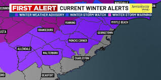
Distinct counties such as Williamsburg, Clarendon, northern Berkeley, and Orangeburg could emerge as focal points for ice accumulation, with possible totals nearing up to .10 inches. Beyond these zones, a light sheen of icy coatings could extend eastward but steer clear of coastal areas. The timeline for icing concerns spans Saturday evening through the morning hours of Sunday, although most coastal territories are anticipated to maintain temperatures above the freezing mark. Sovine emphasizes the light and scattered nature of the anticipated precipitation bridging Saturday to Sunday.
As the forecast unfolds, precipitation is predicted to taper off by Sunday night into Monday as a cold front sweeps through. Post-precipitation, a swift descent into frigid temperatures is projected, heralding the arrival of arctic air as Monday transitions into Tuesday. Overnight lows are anticipated to plunge into the teens towards regions west of I-95 and substantial parts of the Francis Marion Forest, with coastal vicinities likely experiencing low to mid-20s readings. The looming wind chills could dip into the mid-upper teens, possibly leading to a Cold Weather Advisory issuance for the entirety of the affected areas, contributing to a prolonged spell of cold weather throughout the upcoming week.
In parallel developments witnessing a spreading influence across South Carolina, North Carolina, and Georgia, an impactful ice storm looms large on the horizon. The scenario unfolding overnight from Saturday into Sunday ushers in a phase marked by freezing rain and sleet, with appreciable ice accretion already starting to materialize. The ensuing transition into Sunday foresees expedited ice build-up, amplified by escalating winds that could strain trees and power lines, thereby elevating the likelihood of power outages and exacerbating travel disruptions.
The widening ramifications stretching into Sunday evening sketch a potential heightening of ice accumulations, with some areas possibly approaching or exceeding formidable marks of ¾ to 1 inch. Despite precipitation cessation as Sunday wanes into the onset of the week, the persistent grip of cold air sustains the pervasive chill, warranting vigilance against refreezing implications and lingering impacts on the roadways.
Emphasizing the protracted and high-impact essence of this unfolding winter storm, the situation remains fluid and poses lingering threats even post-precipitation. Vigilance, preparedness, and a readiness to adapt characterize the essential approach for individuals navigating the evolving climatic challenges. The intricate dance of weather patterns orchestrated by this storm necessitates a meticulous eye on the forecasts, underscores the paramount urgency in community readiness and highlights the fluid nature of prevailing conditions.
Amid this tempestuous backdrop, the accurate forecasting prowess of the WYFF News 4 weather team navigates the storm's nuances with seasoned precision, affirmed by an independent certification accolade marking them as a reliable benchmark in the Greenville-Spartanburg-Asheville-Anderson market. The WeatheRate endorsement underscores the channel's steadfast commitment to precise forecasting, amplifying its credibility as a trustworthy source in an arena renowned for its meteorological caprices.
Led by Chief Meteorologist Chris Justus, the WYFF 4 weather team's mettle and dedication underscore their ability to decipher the region's complex weather dynamics, steering viewers through the storm's labyrinth with unwavering accuracy. Harnessing the power of internally managed live radar technology, Live Super Doppler 4, WYFF News 4 primes itself as a regional weather authority, paving the way for informed decision-making amidst the swirling maelstrom of inclement conditions.
As the impending winter storm gains momentum, the renderings of the National Weather Service paint a somber picture, designating the timeframe from Jan 24 to Jan 25 as a period fraught with heavy precipitation threats, alongside the looming specter of freezing rain, sleet, and ice entwined within the storm's arduous grip. The evolving forecasts unfurl a narrative of the shifting weather dynamics, underscoring the tempest's relentless advance and urging residents to brace themselves for the potentially severe weather onslaught sculpting the weekend landscape.
In light of the preemptive state of emergency declaration by Governor Henry McMaster and the concerted efforts of the state agencies and emergency management divisions, a cohesive strategic response architecture has been mobilized, upholding public safety as the paramount imperative in the face of the impending storm's fury. Mindful preparedness, community engagement, and a collective resolve to weather the storm harmonize the multifaceted responses vital in navigating the challenges scripted by the unfolding meteorological saga.
The evolving saga underscores the critical importance of staying attuned to the latest updates, monitoring the oscillating weather patterns, and heeding the advice from meteorological experts steering the region through the throes of the high-impact winter storm. As South Carolinians brace themselves for the impending trials, the cohesive community response, informed decision-making, and preparedness underscore the quintessential requisites in weathering this formidable meteorological crucible shaping the wintry weekend narrative.