Severe storms in the South have been causing chaos, with flash floods and tornadoes threatening many areas across the region. FOX Weather Meteorologist Kiyana Lewis has been providing live updates on the situation as communities brace themselves for the impact of these extreme weather events.
In Jackson, Mississippi, and various other states in the South, severe storms have been raging, triggering Tornado Warnings and a high risk of flash flooding. The heavy rain has led to flash flood advisories in Louisiana, Mississippi, and Alabama, saturating regions that have been experiencing drought conditions and heightening the risk of flooding.
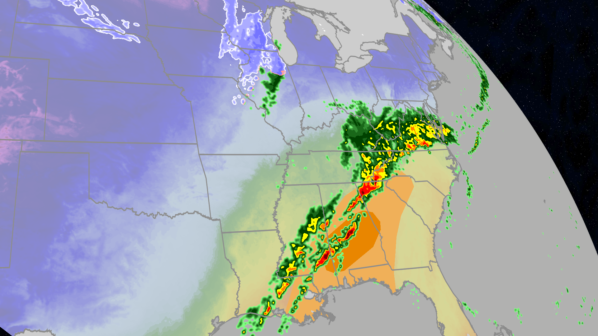
The Southern region has been experiencing multiple rounds of severe storms stretching from the Tennessee Valley to the Gulf Coast. The potential for flash flooding is particularly concerning in Southern Mississippi, close to areas like Hattiesburg and Jackson, where rainfall rates could reach up to 3 inches per hour. To address this threat, flood watches have been put in place through Saturday, covering a distance of over 600 miles from New Orleans to Nashville.
Approximately eight million people are under a 2 out of 5 severe storm risk on Friday, specifically in parts of Louisiana, Mississippi, and western Tennessee. The area at the highest risk extends from Baton Rouge, Louisiana, through Memphis, Tennessee, and east to Birmingham, Alabama. While damaging wind gusts are expected to be the primary threat, the possibility of more tornadoes remains on the radar after a series of tornadic episodes on Thursday and Friday.
The day started with a potent line of thunderstorms spawning at least two confirmed tornadoes in Mississippi early in the morning. As a cold front from a cross-country storm delivered heavy rain to parts of the South and Gulf Coast, the severe storms intensified, impacting a large area with high winds and torrential downpours.
Meanwhile, further North in Oklahoma, a powerful EF-2 tornado tore through Purcell on Thursday, leaving a path of destruction in its wake, including downed power lines and uprooted trees. The National Weather Service confirmed several more tornadoes in Oklahoma, emphasizing the impactful nature of these severe weather events.
As the storm system moves eastward, a level 2 out of 5 severe storm risk remains in place into Saturday, focusing mainly on Central and Southern Alabama as well as Western Georgia. The storm is predicted to progress towards the Carolinas, potentially impacting events like the NFL playoffs match-up between the Carolina Panthers and the Los Angeles Rams.
Looking ahead, the storm's exit from the region does not eliminate the risk of flash flooding, with areas in East Tennessee and Western North Carolina still under threat. The severe weather pattern that has been sweeping through the South is part of a larger storm system that is expected to impact various regions across the country.
As the storm system progresses, a mix of severe weather, including snow in some Northern areas, heavy rain in the East, and strong winds throughout the Midwest and East, will persist over the weekend. The timing and extent of these weather events are crucial to understand the potential risks and impacts on different regions.
Overnight into Saturday morning, the frontal system will continue to pose threats of severe storms and flash flooding across the Gulf Coast and the Southeast. The forecast extends to include snow in the western Great Lakes and upper Midwest, along with more rain spreading into the East and potential strong winds in the Midwest and East.
Locally heavy rain in the Deep South may lead to flash flooding, especially in regions like southern Mississippi and western Alabama. Though snowfall is expected in parts of the Great Lakes and northern New England, the lack of cold air means it won't be a significant snow event. Additionally, isolated severe thunderstorms with strong wind gusts and tornadoes are possible, extending to parts of the Carolinas on Saturday afternoon.
Strong winds with gusts over 40 mph are anticipated on Saturday, with a continued impact in the Midwest and East on Sunday. These winds could result in downed trees, power outages, and challenging driving conditions, particularly in areas with snowfall.
Overall, the severe weather patterns seen in recent days highlight the importance of preparedness and awareness as communities navigate the risks posed by these extreme weather events. Our ability to stay updated on the latest forecasts and heed the guidance of meteorologists is crucial in safeguarding lives and property during such weather events.