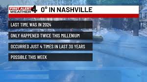
Nashville, Tennessee is bracing for a powerful winter storm set to hit over the weekend, bringing a mix of snow, sleet, freezing rain, and rain. Following the storm, temperatures are forecasted to potentially plummet to zero, a rarity in Nashville. The city rarely experiences zero-degree temperatures, with the last occurrence in 2024 and before that in 2022. Looking back to the 1990s, zero-degree readings were even more infrequent, with just a couple of instances this millennium. The presence of a snowpack significantly increases the likelihood of hitting zero degrees in Nashville. Snow cover acts as insulation, preventing the Earth's heat from escaping and helping to warm the lower atmosphere. Additionally, snow reflects sunlight, reducing daytime heating.
Tuesday morning in Nashville is anticipated to be bitterly cold, possibly marking the coldest period in months. Across many areas, temperatures will drop close to or below zero degrees, making it crucial for residents to take precautions.
In order to stay informed about potentially life-threatening weather conditions, residents are encouraged to download the WSMV 4 First Alert Weather app, available for both iPhone and Android devices. This app offers personalized weather alerts, detailed forecasts, and informative videos about upcoming weather events. Users can also share their weather-related pictures and videos through this platform.
Moving to the weather forecast for the upcoming weekend, the recent cold front that passed through on Friday led to temperatures dropping below freezing by the evening hours. Although the front may have brought a brief shower or two, significant precipitation was not expected. Friday saw mostly cloudy conditions with high temperatures reaching the mid to upper 30s. As the weekend approaches, showers are expected to move in late Friday night into Saturday morning, with overnight lows dropping to the upper teens.
The weekend continues to be a focal point in the weather outlook, with the storm set to bring snow on Saturday morning for most areas. Throughout Saturday, the freezing rain line is forecasted to advance northwards as temperatures moderate. A critical threshold appears to be around 20 degrees, with temperatures above leading to freezing rain or sleet, while temperatures below are likely to result in snow.
Sunday poses a more complex forecast, with the expectation of sleet and freezing rain predominating across West Tennessee. Areas closer to Kentucky may experience higher snow totals compared to other regions. The proportion of sleet versus freezing rain will determine the severity of the ensuing ice storm. Additionally, some areas might witness final snow showers late Sunday morning or in the afternoon as the system clears out, making way for a significant cold front to set in.
Following the storm's departure, a prolonged period of cold weather is expected to settle in, with temperatures forecasted to plummet to around 0 degrees on both Sunday and Monday nights. Furthermore, strong winds are expected to create wind chills ranging from -10 to -20 degrees at times. Considering these extreme conditions, residents are advised to stay indoors from Friday night onwards and to ensure ample supplies to last through the cold spell. Some areas may face challenges with snow and ice accumulation extending into the middle of the following week, requiring vigilance and readiness from residents.
Meteorologist Joel Barnes provides updates and insights on the evolving weather conditions through various social media platforms, including Facebook, Twitter, and Instagram, keeping the community informed and prepared for the impending weather challenges.
As the winter storm approaches, Nashville residents are urged to stay vigilant, prepared, and connected to reliable weather information sources to navigate the potentially hazardous conditions expected in the coming days.