The recent winter storm that hit New York City and the surrounding areas left a thick blanket of snow that turned into ice and freezing rain, creating hazardous road conditions. The National Weather Service issued Winter Storm Warnings for Lower Hudson Valley, Southern Connecticut, and northwestern parts of NE New Jersey, while a Winter Weather Advisory was in effect for the rest of the area, including New York City. Eyewitness News Chief Meteorologist Lee Goldberg mentioned that this storm was expected to bring more snow compared to the previous storm that hit on Thursday, especially in the northern regions. The snowfall was projected to range from a coating to 2 inches south of New York City, 2-4 inches in the NYC metro area, northern New Jersey, and Long Island, and 4-8 inches north of the city.
In response to the storm, a Travel Advisory was issued in New York City on Saturday night. Mayor Eric Adams assured residents that city agencies were prepared to keep New Yorkers safe during the snowfall and freezing temperatures. The Department of Sanitation declared a Snow Alert, activating a high-level snow-fighting response, with thousands of staff working on 12-hour shifts to spread salt, attach plows to collection trucks, and operate the snow plows when snow depths reached two inches. Over 700 salt spreaders were ready for deployment, with the Department having approximately 700 million pounds of salt stocked up. Additionally, the Department was equipped with new high-tech methods to monitor snow operations efficiently.
The storm was forecasted to continue into the following week, with potential snow on Tuesday afternoon and night, followed by a wintry mix transitioning to rain on Thursday. Eyewitness News encouraged residents to stay informed with updates on the ongoing winter weather through their AccuWeather reports.
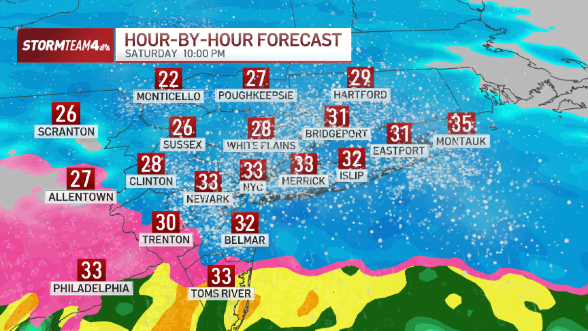
As the storm approached and snow accumulation began, the timeline for the storm's impact in the NYC area was detailed. Winter Storm Warnings and Winter Weather Advisories were put into effect at different times on Saturday evening. Snowfall intensified overnight, with rates of 1 to 2 inches per hour expected, leading to hazardous road conditions. The transition from snow to sleet was forecasted for early Sunday morning, followed by a rise in temperatures causing a shift to freezing rain and sleet. The storm was anticipated to gradually subside by Sunday morning, with the warnings and advisories lifted by midday. The National Weather Service suggested the possibility of another snowstorm system later in the week.
The snowfall predictions varied across the tri-state area, with estimates ranging from 2 to 5 inches in New York City to 5 to 8 inches in the northern inland regions. However, the final snow accumulation was contingent upon surface temperatures during the storm, potential banding effects, and the movement of the wintry mix. The active weather pattern expected to persist into the following week raised the possibility of higher snowfall totals in the NYC area, with continued uncertainty regarding the precise track and type of precipitation for subsequent storm systems.
The storm was expected to start around 7 p.m., with snowfall rates potentially reaching an inch per hour. By midnight, the snow was likely to transition to a mix of sleet and rain, which would clear out by Sunday morning. While the storm system was predicted to move swiftly through the region, leaving only minor flurries behind, residents were urged to stay alert and monitor updates provided by local meteorologists for any changes in the weather conditions.
In conclusion, the recent winter storm in New York City and the tri-state area brought significant snowfall, causing disruptions and challenging conditions on the roads. With preparations in place and continuous monitoring of weather patterns, residents and authorities remained vigilant to ensure safety and effective snow management. As the region braced for potential future snow events, staying informed and being prepared for further inclement weather remained essential for all individuals in the area.