An unusually powerful March storm is currently making its way across the country, bringing with it a diverse range of potential hazards. From strong winds capable of triggering blizzard conditions and dust storms to severe thunderstorms that could spawn tornadoes, this disruptive storm is causing concern for many regions.
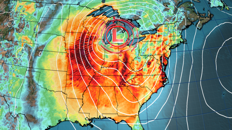
Initially building over the Rockies early Monday, this storm is expected to strengthen and expand over a significant portion of the central US by Tuesday morning. The storm's southern side is likely to give rise to severe thunderstorms, while wintry weather is expected in its northern areas.
Of particular note is the fact that this storm poses the first significant challenge for the National Oceanic and Atmospheric Administration cNOAAc and its National Weather Service following recent cuts to staff. The staffing reductions enforced by the Trump administration have sparked concerns among scientists who warn of the potential dangers to public safety. Around 800 employees were laid off across NOAA last week, raising worries about the agency's ability to adequately respond to weather-related emergencies.
As the storm progresses, it is forecasted to intensify further, potentially reaching "near record strength for March" as it moves eastward through the eastern half of the US by Wednesday and Thursday, according to the Weather Prediction Center.
What can we expect each day as this storm unfolds? Wind speeds are set to ramp up on Monday, especially in the Rockies and parts of the Plains. With speeds potentially reaching 60 mph, there is a risk of power outages and localized damage. Alongside the strong winds, the Storm Prediction Center has issued a level 3 out of 3 extremely critical fire weather risk alert for parts of eastern New Mexico and western Texas, where dry conditions and gusty winds could escalate the danger of wildfires.
In southern New Mexico, blowing dust from dry land has already caused hazardous road conditions and visibility issues, prompting the shutdown of interstates. Meanwhile, thunderstorms are expected to develop from Texas to Kansas, bringing a significant threat of damaging wind gusts, large hail, and tornadoes across the southern US.
As the storm progresses, severe thunderstorms capable of producing damaging wind gusts, hail, and tornadoes are anticipated in various regions. States like Louisiana, Arkansas, and Mississippi are under a level 3 out of 5 risk of severe thunderstorms, with the potential for strong tornadoes and wind gusts exceeding 70 mph.
The impact of the storm extends to popular festivities such as Mardi Gras in the New Orleans area, where severe weather may disrupt celebrations. In anticipation of the hazardous conditions, local authorities have canceled parades and adjusted schedules to ensure public safety.
As the storm moves towards the Southeast, the risk of severe thunderstorms, damaging wind gusts, and tornadoes persists. Further north, snow and strong winds are expected to pummel the Plains while severe thunderstorms continue in the southern regions, presenting a varied mix of weather hazards across the country.
Looking ahead, the storm is slated to reach the East Coast by Wednesday, affecting millions of people from Georgia to Pennsylvania and New Jersey. With potential risks of severe thunderstorms, damaging winds, and tornadoes, the storm's impact will be widespread, disrupting daily life and travel for many individuals.
In light of the hazardous weather conditions brought about by this powerful storm, it is crucial for individuals to stay informed and take necessary precautions to ensure their safety. With the storm's wide-reaching effects and the unpredictability of severe weather patterns, vigilance and preparedness are key in facing such natural phenomena.
The latest updates on the storm and its impacts are vital for communities to stay ahead of the changing weather conditions and potential risks associated with this powerful storm system. As the storm continues to progress, staying tuned to reliable sources for weather alerts and guidance is critical for navigating through the challenges posed by severe weather.