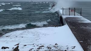
A storm system continues to impact Michigan, bringing heavy snow, ice, and strong winds to both the Upper Peninsula and northern Lower Peninsula. The National Weather Service reported that some areas have already received over 8 inches of snow, with more expected through Wednesday morning. Gale warnings are in effect for lakes Superior, Michigan, and Huron, along with a portion of Lake Erie. The eastern Upper Peninsula is under a winter weather advisory, while other areas have wind advisories or hazardous weather outlooks in place.
In the western Upper Peninsula, locations in the Keweenaw Peninsula experienced significant snowfall, ranging from 2 to 8 inches. The rest of the Upper Peninsula is also expected to see snowfall tapering off by April 16. In the Lower Peninsula, Traverse City to Cadillac and Houghton Lake to Mackinac City are under a winter weather advisory. Despite the wintry conditions, the NWS office in Marquette stated that as the snow diminishes, strong northwesterly winds with gusts up to 45 mph may persist along the Lake Superior shoreline, calming down as high pressure builds in.
Looking ahead, a cold system will move through Michigan, bringing the potential for snowfall even as far south as Ann Arbor and Detroit. While this storm may not result in significant snow accumulation, the late arrival of wintry weather in mid-April may still bring surprise to residents. The precipitation is expected to be a mix of rain and snow, with varying accumulation levels forecast across different regions of Lower Michigan.
Total snowfall forecasts indicate that most areas will receive minimal snow accumulation, with the Thumb, Oakland County, and Genesee County potentially seeing up to an inch of snow on grassy surfaces. Northwest Lower Michigan areas, including Cadillac, Traverse City, Kalkaska, and Gaylord, could receive up to two inches of snow. Temperatures are expected to drop significantly, with highs only reaching the 30s and 40s, creating cold and windy conditions reminiscent of winter.
Despite the wintry mix, the storm is not anticipated to significantly disrupt daily routines, except for potential impacts on outdoor activities like planting. The chill from the cold temperatures, coupled with gusty northwest winds exceeding 30 mph, will result in wind chills in the 20s, adding to the discomfort of the late-season snowfall. However, sunshine and fair weather are on the horizon as the system moves out of the region, with quiet conditions and clearer skies expected in the days following the storm.
Looking further ahead, temperatures are forecast to remain cool in the 40s with more sunshine expected later in the week. Apart from a scattered rain event on Friday, the weekend is likely to be calm and sunny. As Michigan experiences this unexpected late-winter blast, residents are advised to stay informed about changing weather conditions and be prepared for potential impacts on travel and outdoor activities in the affected regions.