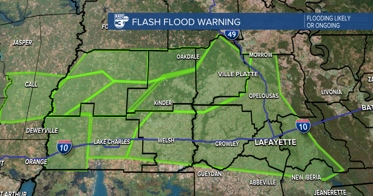
Severe weather has hit southern Louisiana with a vengeance, bringing heavy rains and the threat of localized flooding. Flash Flood Warnings have been issued for several parishes extending from St. Martin Parish westward along I-10 into Calcasieu and northward into Evangeline Parish. The heaviest rainfall has been reported in Calcasieu and Beauregard Parish, leading to numerous flood reports. However, flooded roads have also been reported in other areas such as Opelousas, Jennings, and Ville Platte, prompting a plea for caution while driving.
The rain is expected to persist across Acadiana, posing a continued risk of flooding throughout the morning. Some areas have already received between 3-7 inches of rain over the last 12 hours, with isolated pockets in north Acadiana experiencing even higher rainfall totals. While the line of showers has shifted slightly southward, providing some relief in drainage, the saturated ground remains a concern.
The radar indicates that the boundary for showers lies along the I-10 corridor, suggesting that most of the rainfall will develop south of this line. The variations in rainfall intensity, from light drizzles to downpours, create challenges for road conditions. As the ground becomes increasingly saturated, the risk of rapid pooling and flooding escalates during heavy rainfall periods.
River levels are rising, with the Vermilion River reported to be approximately 2 feet above flood stage and continuing to climb. Minor flooding is anticipated in areas like Beaver Park and Vermilionville, and the situation will be monitored closely as the river reaches critical levels.
While the rain is expected to taper off in the afternoon, scattered showers may persist over the next few days. There is a possibility that a front will stall just offshore, diverting more rain into the Gulf. However, a northward shift could bring additional showers back over land. The weather pattern is predicted to clear out by the weekend as a front moves the system out of the region.
In addition to heavy rainfall, thunderstorms have the potential to bring damaging winds, hail, and localized flooding across parts of Louisiana, Mississippi, and Alabama. Drivers are cautioned against attempting to traverse flooded roads as the water levels can be deceptive, leading to dangerous situations. Emergency services advise turning around and avoiding flooded areas to prevent vehicles from becoming trapped or inundated in minutes.
As the severe weather unfolds, the importance of staying informed and prepared cannot be overstated. A Flood Watch is in effect for southeast Louisiana and southwest Mississippi, and residents are urged to have reliable ways to receive weather alerts. Keeping electronic devices charged and updated with relevant apps for weather monitoring is recommended. Direct communication channels through websites, social media, and apps are crucial for receiving real-time weather updates and safety tips during such weather events.
In conclusion, staying vigilant, informed, and prepared is key during severe weather conditions to ensure personal safety and mitigate risks associated with flooding and storms. Following recommendations from local authorities and meteorological services can help individuals and communities navigate through inclement weather more safely and effectively.