Mark Strehl has your weather update for the Chicago area! Following a mild Saturday, residents should gear up for warmer weather as high pressure shifts east to usher in a surge of warm air on Sunday. Forecasts indicate mostly sunny skies in the morning, transitioning to partly cloudy conditions by the afternoon. Temperatures are expected to soar into the mid-80s, with lakeshore areas experiencing slightly cooler conditions and overnight lows hovering around 72 degrees.
Although most parts of the region are likely to remain dry, there is a slim chance of isolated showers or thunderstorms cropping up late Sunday night through early Monday morning. Areas to the north and west, including sections of Wisconsin, Minnesota, and eastern Iowa, have already witnessed more widespread storm activity.
Looking into the week ahead, expect seasonably warm and humid conditions, with temperatures ranging from the mid to upper 80s and a mix of sun and clouds leading up to Friday. Scattered showers and storms may make intermittent appearances, particularly during the overnight hours. Present storm models indicate a reduced risk of severe weather at the start of the week.
Following a brief reprieve from humidity, the Chicago area is poised to experience an uptick in dew points on Sunday, coinciding with the potential for strong-to-severe thunderstorms. Dew points are anticipated to peak in the low-70s, accompanied by rising air temperatures reaching the low-90s across the region.
This combination could drive heat indices above 100 degrees, marking a warm finish to the weekend and setting the stage for potential thunderstorm development later in the day. While any afternoon or evening thunderstorms may be isolated, the heat and humidity could bolster their intensity. Areas to the north and west of Chicago are under a "marginal" risk of severe weather, as indicated by the Storm Prediction Center.
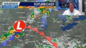
A special weather statement has been issued for northern and central Cook County as a line of thunderstorms, marked by wind gusts up to 45 miles per hour and small hail, moves through the region. Suburbs like Winnetka and Evanston could be affected, with potential impacts on revelers at Chicago's Pride Parade on the North Side.
The primary threats associated with these storms would be gusty winds and heavy rainfall, according to forecast models. Monday also poses a threat of severe storms, with the entire Chicago area falling under a "marginal" risk. Gusty winds, heavy rain, and frequent lightning are expected to be the main concerns, with storms arriving alongside a cold front that will eventually usher in cooler temperatures and disperse the impending humidity.
Tuesday will bring a reprieve with cooler, less humid conditions, featuring highs in the low-80s and mostly sunny skies. This pattern is expected to persist through Friday, when temperatures are projected to climb just in time for the Independence Day holiday. Extended forecast models suggest temperatures could reach the low-90s, offering plenty of sunshine for holiday celebrations.
For the latest weather updates, stay connected with the NBC 5 Storm Team and download the NBC Chicago app for real-time weather alerts directly to your mobile device. Stay informed and prepared with the most up-to-date information on Chicago's weather patterns.