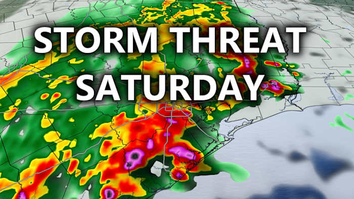
Houston and the surrounding areas in southeast Texas were hit by a round of severe storms early in the morning, resulting in winds exceeding 50 mph that left over 167,000 Centerpoint customers without power. Reports also indicated incidents of fallen trees and power lines in some locations, with Grimes County near Anderson experiencing home damages caused by a confirmed tornado.
The National Weather Service cNWSc reported an EF-0 tornado touching down near Anderson, Texas, around 2:30 a.m. Saturday, highlighting the intensity and impact of the weather system. Following this initial event, a subsequent round of storms was forecasted to move through southeast Texas later in the evening, with the expectation of reaching specific areas at different times. Bryan/College Station was likely to experience severe weather between 6-9 p.m., while downtown Houston was anticipated to be impacted around 10-11 p.m., with the storms moving offshore after midnight.
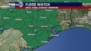
The severe weather threat led to the continuation of a flood watch until early Sunday, underlining the potential risks associated with the ongoing weather patterns. The forecast also pointed towards isolated severe storms with the possibility of wind and hail during the evening. As meteorologists monitored the situation closely, viewers were encouraged to stay informed through live hourly updates and radar streams, ensuring preparedness and safety during these meteorologically active times.
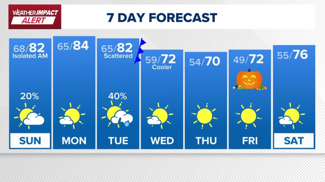
Looking ahead, a refreshing cool front was projected to follow the stormy conditions, promising pleasant temperatures and calmer weather by the upcoming week. Temperature drops were anticipated, with lows possibly reaching the 50s and even some areas likely to experience temperatures in the 40s by Friday morning. The outlook for Halloween hinted at cool and dry conditions, signaling a shift towards more autumnal weather conditions in the region.
In parallel to the local weather developments, the Atlantic Ocean was also experiencing its own weather-related events, as Melissa transformed into a hurricane and was forecasted to escalate into a major hurricane within the next 24 hours. The slow movement of the storm system was predicted to result in flooding in Jamaica before the onset of very high winds, potentially affecting the island with hurricane force winds for an extended period—a rare occurrence for the region. However, the storm was expected to veer into the Atlantic Ocean subsequently, with minimal implications on the Gulf Coast of the United States.
Amidst the tumultuous weather updates, residents were advised to stay vigilant and prepared for any unexpected changes while also appreciating the intricacies of weather prediction and tracking technology that enabled timely warnings and updates to be disseminated to the public. The convergence of various weather phenomena underscored the importance of staying connected to trusted weather sources and maintaining awareness during periods of uncertain weather conditions.